Monday, June 11, 2012

DAY-5 REPORT: 6/10/12: Burnt Rancheria to Overlook at Oasis Spring (6.3 mi)

TOTAL PCT MILES COMPLETED AFTER THIS HIKE:  47.7 Miles


THE GOOD: Easily the best views of all the hiking so far.  The first half of the hike being almost entirely under the trees and in shade.  The hike has a net downhill of about 500', easy grades.
THE BAD: The last section that is all downhill snakes back and forth and takes forever to get back to the car.  But it's a beautiful area, so it's not bad at all,  I just couldn't think of anything else that I could say was bad.
AND THE ABSURD:  Sharing the trail with runners near the end of their 100-mile ultramarathon.


Shade, glorious shade!
Start temp approx 75-degrees and stayed more or less the same throughout the hike.   Great hiking weather!  Decent breeze blowing helped keep us cool.  Start time 9:20am, finish time 1:00pm (3.3-hours.)  Atticus walked about a mile of it in total, so we went a bit slower than we could have had we carried him the whole way.


Looking west, overlooking the forest of Laguna Recreation Area
Only 4-people on this hike, ourselves and Rosalind. As was reported on the hike from yesterday, we spent this weekend camping at Burnt Rancheria Campground so we were able to star this hike directly from our camp after leaving our shuttle car at the overlook above Oasis Spring, alongside the Sunrise Highway.  A very short drive to leave the shuttle car.  We got a bit of a later start this morning as it was cooler than on previous hikes and we did a bit of packing of our gear first.  And, enjoyed a second cup of coffee.  Or was it a third?


Dropping down towards the saddle overlook
The first half of the hike was in the shade of trees, and beautiful except for the occasional sound of vehicles along the Sunrise Highway nearby.  The very first section of the hike is also called the "Desert View Trail", aptly named.  Great first views of the desert.  


At the overlook at the saddle, Sawtooth Range in the back left.
Once we eventually emerged from the forest, and back into the Chaparral, the views all around were fantastic.   Eventually we dropped down to a saddle where a short spur trail to the right lead to an amazing overlook above the desert.  If you do this hike, be sure not to miss visiting this spot.


Breathtaking views at the saddle
Everyone is happy here


San Felipe hills faintly seen at end of arrow.  
Likewise, when you start dropping down towards where the car is parked there is a short spur to the right that leads to Foster Point (it is signed, so it is not easiliy missed.)  There is a monument there which points out all the mountains and ranges that can be seen from that point.  It's hard to make out, but we could see the San Felipe hills from there, where will will end up hiking once the weather cools down again in fall or early winter.


Atticus leading the way downhill
After completion of the hike, it's great to get a Blackened Burger and a cold beer (they have great bottled IPA's) at the Pine House Cafe & Tavern.  They also have Hard Julian Cider that is quite nice as well.  And, don't forget the showers at Burnt Rancheria Campground!
Atticus and Rosalind having a good moment together


Speaking of which, you can park at the showers at the campground, as long as you have an Adventure Pass.  There are a few designated spaces there for Adventure Pass holders.


This is the shortest, but the most scenic, hike we have done so far on the trail.  Worth the wait!


Click HERE for our hike as recorded by GPS.  Note that the GPS battery went dead during the hike so the data is incomplete.

DAY-4 REPORT: 6/9/12: Cibbets Flat to Burnt Rancheria (9.6 mi)

TOTAL PCT MILES COMPLETED AFTER THIS HIKE:  41.4 Miles


The happy crew today, with Rosalind and "New Steve"
THE GOOD: Great vistas all along the trail.  Being able to see Lake Morena WAY behind us, and seeing all the pine forests we were going to eventually end up in.
THE BAD: The crossing at Long Creek doesn't really have any shade trees for enjoying lunch under.  Better to stop just a bit earlier in Long Canyon to find a tree to sit under for lunch.
AND THE UGLY: Biting flies again, during lunch at Long Creek.


Our destination, just about here at the arrow
Start temp approx 64-degrees.  Forecast high was 79 degrees but eventually it was at least 10-degrees in excess of that.    Decent breeze blowing helped keep us cool.  Start time 8:20am, finish time 1:45pm (5.5-hours.)  Took a bit longer than anticipated because the total climbing is 2400', so we had a slower pace.  It's not a grueling steep hike, just steady uphill with a few short, steeper sections.


On the trail, using a "StickPic" widget to take the picture
We decided to do something fun and different for this hike and the next (to occur the next day, on Sunday.)  We went up Friday night and set up camp at Burnt Rancheria Campground.  This way we could finish a hike at camp on Saturday, and start a hike from camp on Sunday.  Great way to do the hikes in this area.  Plus, there are showers at the campground after hiking!


Looking southwest, Lake Morena WAY back there under the arrow
5-people on this hike including Atticus.  Besides ourselves, Rosalind and "another" Steve joined us (this was the first hike with "New Steve".)  "Old Steve" and Daniel couldn't make it on this hike.  We met at Cibbets Flat at 8:00am and did not need to start with a shuttle as we had Rosalind's car back at the camp at the end of the hike.   Kitchen Creek Rd. is permanently gated now, so we had to drive 1/2 hour from Burnt Rancheria all the way down Sunrise Highway to Hwy 8, then go east to Kitchen Creek Rd. Exit, then up that road to Cibbets Flat Campground.


The trail alongside Long Creek, a nice and shady section
The hike begins with a nice walk through the campground, and catches Fred Canyon Road at the top of the campground.  Then it's steeper hike up the road for about 0.65 miles to where the PCT crosses the road.  The PCT starts off a bit steep, then eventually levels off and is surprisingly level.  Great views along this stretch before winding down towards Long Creek.  


Lunch at Long Creek at the closest shady spot we could find


There are a few spots above the creek where you can have lunch under a tree, or there a nice spot later (after the creek crossing) where you can have lunch (later described here.)  We had lunch at the crossing of Long Creek and got bit by flies yet again.  Our bug spray didn't seem to work very well to keep them away.


"New Steve" taking a turn with Atticus
The trail climbs quite steeply from Long Creek for a short distance, then passes close by to a nice meadow on the left.  There's a nice oak tree there that could be a great place to stop for lunch.  Eventually the trail reaches the reward of pine forests that provides fabulous shade for the last few miles of the hike.  This is a really nice stretch of trail to be hiking after all the hot chaparral we went through to get here.


Hooray!  The pine forests at last!
One last couple of switchbacks up a slope and then a spur that leads to Burnt Rancheria Campground.  A short hike took us to our camp, more shade, and the cold beers we had been looking forward to.  Just north along the Sunrise Highway, about 50-yards away from the campground entrance, is the Pine House Cafe & Tavern.  They have a great Blackened Burger there, and a nice selection of IPA beers.


Shade and Beers at Camp


This was a great hike!  I had been looking forward to reaching the landmark of making it up to the 600' level of the Laguna Recreation Area.  From here, it's more or less downhill til we get to the desert.


Click HERE for our hike as recorded by GPS.

Monday, June 4, 2012

DAY-3 REPORT: 6/3/12 Lake Morena to Cibbets Flat (13.4 mi)

TOTAL PCT MILES COMPLETED AFTER THIS HIKE:  32.8 Miles


Ridge midpoint between Lake Morena & Boulder Oaks
THE GOOD: Great vistas all along the trail, lots of variation in both terrain and scenery, more oak woodland than anticipated.  And, of course, great company.
THE BAD: Not so pleasant rattlesnake encounter, Rich getting stung by a bee on the back of his head.
AND THE UGLY: Over 10-degrees hotter than forecast.


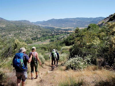
Descending the ridge and towards Cottonwood Creek


Start temp approx 60-degrees.  Forecast high was 78-80 degrees but eventually it was at least 10-degrees in excess of that.  Seldom caught the breeze as we were in the lee behind the terrain for most of the hike.  Start time 8:00am, finish time 4:00pm (8-hours.)  Took longer because of extended lunch break at Kitchen Creek above the falls.


View of the nice flat valley with oak woodland to be crossed.


6-people on this hike including Atticus.  Besides ourselves, Daniel, Steve, and Rosalind joined us. We met at Cibbets Flat at 7:00am, and drove a shuttle car back to Lake Morena.  Funny enough, the drive mileage is longer than the hike mileage.


It's a pleasant hike from Lake Morena all the way to where the trail passes under Hwy. 8.  Fairly flat, and with a morning start a lot of shade under the oak and cottonwood trees.  Midway between Lake Morena and Boulder Oaks Campground there is a ridge upon which the trail climbs and eventually descends, but with an early start this is a very pleasant area to hike with great views along the way.  Water refilling at Boulder Oaks from a faucet there (good tasting water.)
Under the bridge for Buckman Springs Rd and crossing Cottonwood Creek


On our way to Boulder Oaks Campground
Rosalind taking a turn with Atticus


After Hwy-8 the climbing begins quickly.  About 2-miles from Boulder Oaks there is a spur trail off to the left that goes steeply down a few hundred yards to Kitchen Creek, above the point of the waterfall.  This is where we encountered the rattlesnake that had to be coaxed away from the trail.  Gave Allie quite a fright as he was only about 2-feet off the trail, right next to her,  when it started its rattle.  It was coiled up and ready for business by the time I gave it a nudge with my hiking pole to hurry it along his way to elsewhere.  I love seeing rattlesnakes, I think Allie could do without them.  Not sure how Atticus feels about them yet.


Just before the spur trail to Kitchen Creek Falls and lunch. Notice all the flowers in bloom.  Color everywhere!


From where we came:  Lake Morena is below Morena Butte in the background above my finger. We're about half way into the hike here.


Kitchen Creek is a great place to stop, with a nice Cottonwood providing shade right at the creek.  We took off our shoes and soaked our feet in the cool water as we ate lunch.  Because it was so nice, we spent quite a bit of time there before we put our boots back on to start again.


Great lunch spot along Kitchen Creek
The heat of the day really kicked in after lunch, and that could have been because of the time of the day, the specific area we were in, or both.  The trail continues winding up the canyon above the creek, and eventually crosses Kitchen Creek Road.  From there it goes around the east side of a ridge and we were afforded a very pleasant view of Thing Valley and surrounding area.  Trail was quite tight along this section, a bit choked with the flora.  Very interesting rock formations in this area, like fingers of granite all clumped together.


Steve and Atticus soaking them doggies
Before crossing Kitchen Creek Road we were able to spy the pine forests up high in Laguna Recreation Area, our destination for the next hike.  It's going to be nice to get up there!


Cibbets Flat Campground is a great, shady area to enjoy those ice cold beers at the end of the hike.  Well, it's a great place other than getting bit by those darned flies again.  Glad they weren't on the trail all day though, like last time.


Quality sign post after crossing Kitchen Creek Rd


Daniel taking his turn with Atticus, one of them happy, but I think the other is over this hike.


"Well done" to everyone that came on this hike, and thank you!   It was a really fun one, much more so than the last one.  We think that eating a couple of Thermotabs (buffered salt tablets) really helped rejuvenate us. Eating those every few hours shall now become a new part of the process (especially in hot weather.)


Last couple of miles with great views south and east


Almost a good advert for REI Clothing, last few yards at Cibbets Flat